
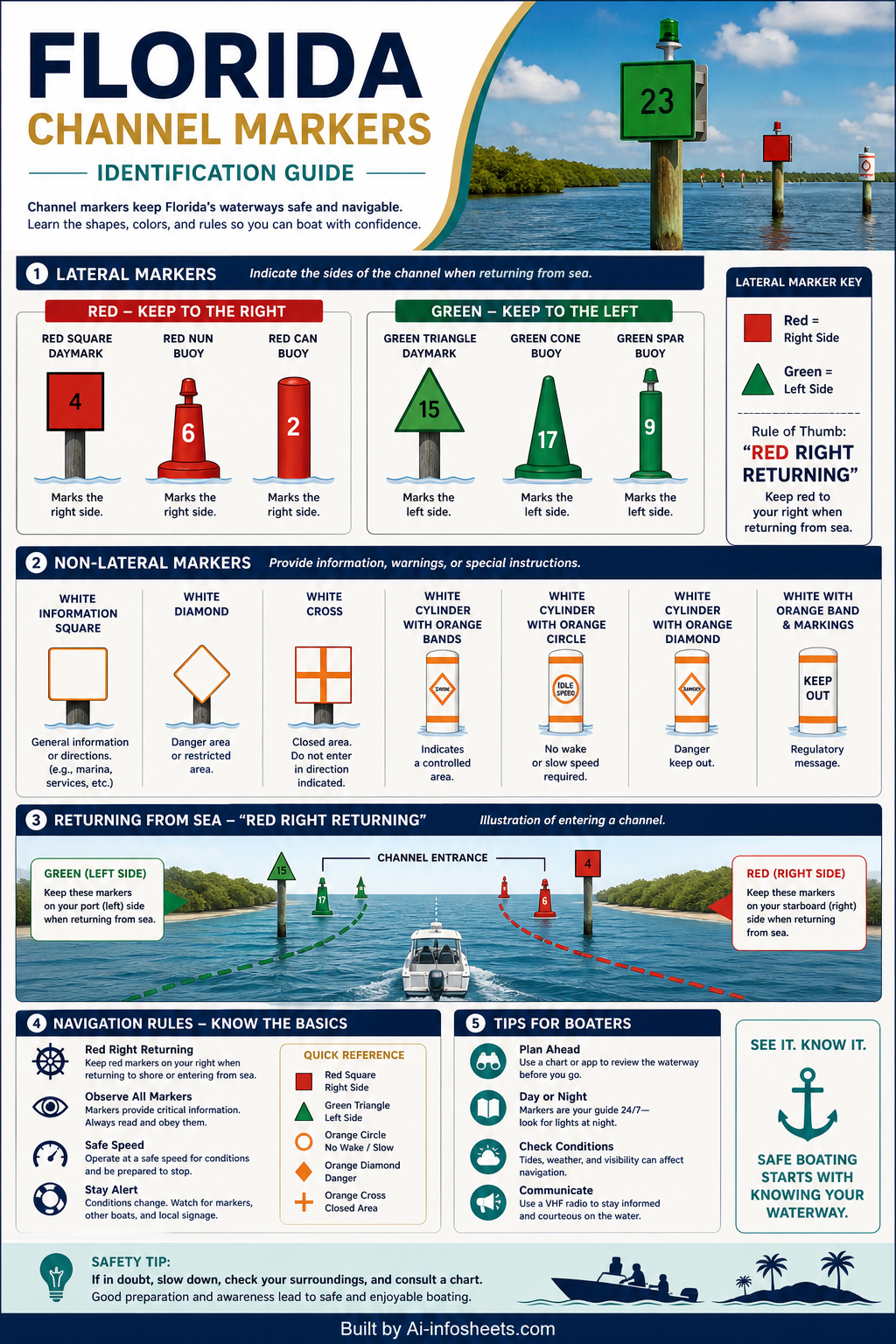


Florida's extensive waterways, from the Intracoastal Waterway to countless lakes and coastal areas, offer unparalleled boating experiences. However, navigating these diverse environments safely requires a clear understanding of the 'rules of the road' on the water, most notably the system of channel markers. These crucial aids to navigation (ATONs) act as the traffic signals of the sea, guiding mariners through safe passages, identifying hazards, and conveying critical information. Properly interpreting their colors, shapes, numbers, and light characteristics is fundamental for preventing accidents and ensuring a smooth journey for all boaters in the Sunshine State.
The Unified S.S. Aids to Navigation System
The United States Aids to Navigation System (USATONS) is primarily employed in Florida waters, maintained by the U.S. Coast Guard, augmented in some areas by state and local agencies. This system is crucial for guiding vessels, demarcating channels, and indicating dangers. Recreational boaters are legally required to understand and adhere to rules pertaining to aids to navigation. It functions on a "Red Right Returning" principle, meaning when returning from the sea, red buoys should be on your right (starboard) side, and green buoys on your left (port) side.
Lateral Markers: Red and Green Buoys
Lateral markers delineate the edges of navigable channels. Their color and numbering indicate which side of the channel they mark. Generally, when returning from the sea (or proceeding upstream on a river), red buoys mark the starboard (right) side of the channel, while green buoys mark the port (left) side. Red buoys are always even-numbered, increasing as you head upstream, while green buoys are odd-numbered, also increasing upstream.
Non-Lateral Markers: Safe Water & Special Purpose
Beyond guiding channel edges, non-lateral markers provide various critical pieces of information. Safe water markers indicate unobstructed water around them, often marking fairways or mid-channels. These are typically red and white vertically striped and may have a spherical topmark. Special purpose markers, on the other hand, convey specific information not related to channel boundaries. These can indicate anchorage areas, scientific research zones, or dredging operations and are often yellow.
Regulatory and Informational Markers
These markers are easily identifiable by their white color and orange symbols, which convey specific instructions or warnings. A diamond shape indicates danger, such as rocks or submerged objects. A circle denotes a controlled area, imposing speed limits or wake restrictions. A square or rectangular shape provides general information, like directions, distances, or locations. It is imperative to heed these markers for safety and compliance with local regulations.
Intracoastal Waterway (ICW) Markers
Florida contains a significant portion of the Intracoastal Waterway, a navigable route along the Atlantic and Gulf coasts. Markers within the ICW system follow the same 'Red Right Returning' principle but also feature yellow symbols. A yellow square on a green marker indicates it should be kept to the vessel's port side when proceeding clockwise around the U.S. coastline (often defined as north on the Atlantic and west on the Gulf). A yellow triangle on a red marker indicates it should be kept to the vessel's starboard side when proceeding in the same direction.
Light Characteristics
Many channel markers are equipped with lights, particularly for nighttime navigation. These lights have specific colors and flash patterns (characteristics) that help identify the marker. Red lights are found on red buoys, and green lights on green buoys. White lights are used on safe water markers, isolated danger markers, and some special purpose markers. Understanding rhythms like flashing, occulting, or quick flashing is vital for accurate identification in low visibility or darkness.
Understanding and correctly interpreting Florida's channel markers is a cornerstone of responsible boating. By familiarizing yourself with these essential aids to navigation, you not only ensure your own safety and that of your passengers but also contribute to a safer, more enjoyable experience for everyone on the water. Before your next outing, take the time to review these principles and always consult current charts for the most accurate and up-to-date information on the waterways you plan to explore.